Evolution of the Town and its Maritime Trade

The earliest recorded maritime trade relating to Woodbridge is from 1350 but the lives of people in this area were entwined with the River Deben, its estuary and the sea from a much earlier date. For many centuries it was maritime trade which drove the expansion of the town.

The Arrival of the Romans

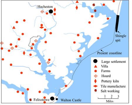
This map shows the locations of all the Roman sites which have been discovered across south east Suffolk. Most were either farms or villas. A large amount of corn was grown in Suffolk and much of it was exported to Gaul from Colchester, or possibly Felixstowe.
Walton Castle, on a cliff by Felixstowe, was one of the forts built to defend the eastern and southern coasts against Saxon raids.
Within the present built up part of Woodbridge and Melton (the area indicted by a dashed line) a coin hoard and traces of a farm have been found.

Location of the Roman sites is south east Suffolk. The built-up part of Woodbridge and Melton is indicated by the dashed line.
Map with pinpoints of Roman sites in Woodbridge area

The Arrival of the Anglo-Saxons

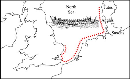
By 410 the Roman troops had withdrawn from Britain and the province was left to fend for itself. The Angles, the Saxons and the Jutes from north Germany then started to settle those areas of Britain that they had formerly raided. They came by the coastal route shown on this map. The journey would have taken 12 to 14 days.

The Romans had introduced Christianity during the fourth century but the new arrivals replaced it with Pagan worship, and Romano-British towns were abandoned in favour of smaller settlements. Some Britons fled to the far corners of the British Isles, while others remained, and integrated themselves with the new arrivals and adopted their language.

The coastal route taken by the Angles, Saxons and Jutes.

Map showing The coastal route taken by the Angles, Saxons and Jutes.
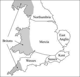
By 600 the seven Kingdoms shown on the map to the left had been created. Christianity had just been reintroduced into Kent and would eventually spread to all the other Kingdoms.

The seven Anglo Saxon kingdoms which which had been created by 600.

Map showing The seven Anglo Saxon kingdoms in UK

The Royal Sites in South East Suffolk

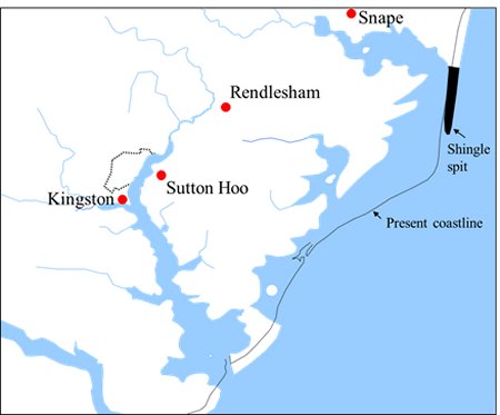
South-east Suffolk became the royal heartland of the Anglo-Saxon Kingdom of East Anglia. The longboat was the Anglo-Saxon’s primary form of transport and the Deben provided easy access into a good agricultural area. The location of the four royal sites in south east Suffolk are shown on this map.

The Wuffinga family provided the rulers of this kingdom until 749 and the ship burials at Sutton Hoo and Snape are believed to be the resting place of the early members of this family. Their Royal Hall was at Rendlesham. The promontory of Kingston was a royal manor where people came to pay their food rents to the king.

The locations of the four royal sites in South East Suffolk. The area was the royal heartland of the Kingdom of East Anglia.

Map showing The locations of the four royal sites in South East Suffolk

The Royal Hall at Rendlesham

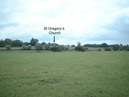
The flood plain of the River Deben at Rendlesham is in the foreground of the photograph to the right. Beyond it the land rises to a plateau by St Gregory’s Church which is indicated by the black arrow. Ongoing archaeological investigations indicate that this plateau was an important place at the time of the ship burials at Sutton Hoo, and that the plateau was probably the site of the Royal Hall mentioned in Bede’s chronicle. From the plateau there is a wide view along the river valley towards Woodbridge and up the river valley towards Debenham.

When Anna became king of East Anglia in 636 he moved the Royal Hall from Rendlesham to Blythburgh, and the Deben valley ceased to be the royal heartland of the Kingdom of East Anglia.

Photograph of the plateau at Rendlesham which was probably the site of the Royal Hall. It is just below St Gregory’s Church. The flood plane of the River Deben is in the foreground.
showing St Gregory's Church

The Royal Manor of Kingston

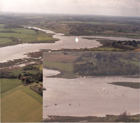
This photograph is an aerial view of a high promontory (now called Kyson Point) which was the Royal Manor of Kingston. The key feature of the promontory is a beach, marked by the white arrow, formed by the Deben cutting into the bank.

Because the rest of the upper estuary was lined by extensive salt marshes, the beach would have provided the ideal landing place for the longboats of those who came to pay their food rents to the king.

The beach marked by
the white arrow was the ideal landing place for longboats.

Arrow pointing to the ideal landing place for longboats.

The Early Anglo-Saxon Settlements in the surrounding area

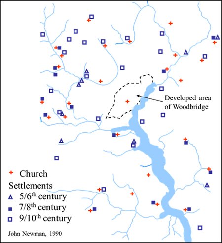
Traces of many Anglo-Saxon settlements have been found around the upper part of the Deben estuary. The locations of these settlements and their dates are indicated by the blue symbols on this map. In most cases the settlements were near churches built during the Anglo-Saxon period. These churches are marked by red crosses.

No evidence of an Anglo Saxon settlement has yet been found in Woodbridge but it is likely to be under the medieval houses near to the church. Although many of the houses now have brick facades their foundations and the layout of the roads have remained unchanged for many centuries.

Hundreds of years of farming and habitation have reduced the signs of the early settlements to scattered pieces of pottery and the occasional pieces of metal work. The only exception in south east Suffolk is at Burrow Hill which is by the coast.

The Anglo Saxon churches and settlements around the upper part of the Deben estuary.

Map showing The Anglo Saxon churches and settlements around the upper part of the Deben estuary.

The Anglo Saxon Settlement at Burrow Hill

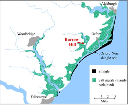
This map below shows the location of Burrow Hill which was at one time an island mainly composed of shingle. The rich farmland which now surrounds it is the result of reclaiming the salt mash which formed when the Orford Ness shingle spit grew and diverted the rivers Alde and Butley.

Map showing the location of Burrow Hill.

Map showing the location of Burrow Hill.
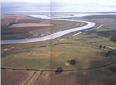
Burrow Hill is in the foreground the aerial view below. The Butley River in the centre and the River Ore and the Orford Ness shingle spit are in the distance. (The River Alde becomes the River Ore when it passes Orford.)

Aerial view with Burrow Hill in the foreground, the River Butley in the centre and the River Ore and the Orford Ness shingle split in the distance.

Aerial view with Burrow Hill

What was Revealed by the Excavation at Burrow Hill

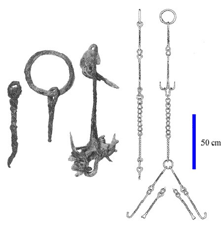
In 1963 the remains of Anglo-Saxon cauldron chain were found, by chance, on Burrow Hill. Parts of the chain, and a reconstruction of it, are shown here. They are both at Ipswich Museum.

A team of archaeologists excavated the site from 1978 to 1981 and found traces of a settlement protected by three V shaped ditches. Within the area enclosed by these ditches there were numerous pits and the post holes of timber framed buildings.

Amongst the objects found on the site were coins from the reign of King Beonna (749 to circa 760). Many of the other objects are on display at Woodbridge Museum, Similar objects would have been used in the settlements which lined the Deben valley 1200 years ago.

Some of the elements of the cauldron-chain found in 1963. They are now on display at Ipswich Museum.

Some of the elements of the cauldron-chain

Buildings

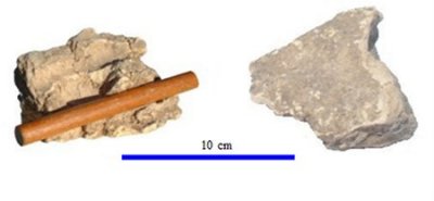
At Burrow Hill, and at other Anglo-Saxon sites, houses were probably based on a frame of oak timbers but these had long since rotted away.  The walls of the houses consisted of a wattle frame with daub on both sides.

Parts of wattle and daub

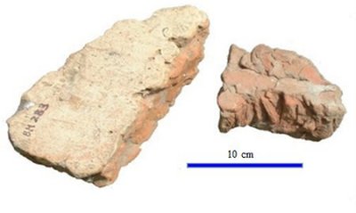
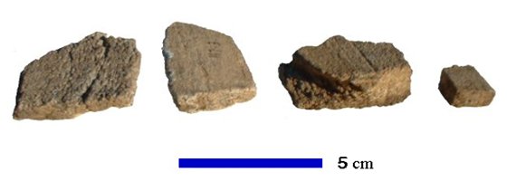
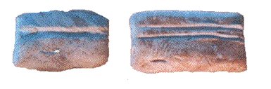
Tiles were made from clay ‘sausages’ pressed together in rows.  The upper surface was then moistened and  smoothed with a board.

Clay sausages

Food

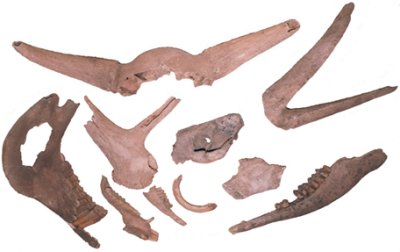
Butchered bones and shells found on the site show which animals, birds and molluscs were eaten. Some of the animals were reared and the others hunted. Young pig was a favourite food as were oysters.

Bones and shells

Part of a meal stone or quern, made from lava imported Germany, shows that grain was ground into flour.

In the cesspits there were burnt rye grains – no doubt from the crispy bottom of a loaf – which had passed through the intestine.

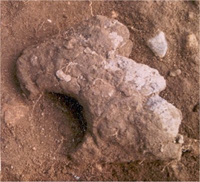
Part of a shaped stone

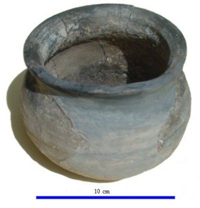
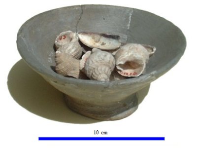
Two of the pots found at Burrow Hill. The presence of kiln wasters indicates that they may have been produced on site.

Historical pot
Historical bowl containing shells

Clothing

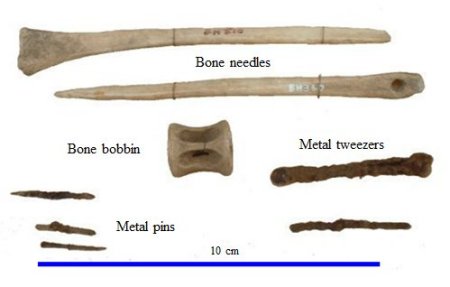
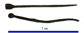
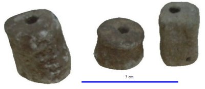
The presence of loom weights, needles and bobbins are evidence of the weaving and working of cloth.

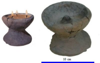
There were lamps which may have been used for textile work or while writing.

Bone needles and metal pins
donut shaped tools
Historical vessels

Headdress pins

Headdress pins

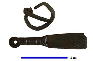
Strap-end and strap-buckle

Strap-end and strap-buckle

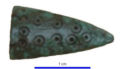
Garter or bandeau fastener

Garter or bandeau fastener

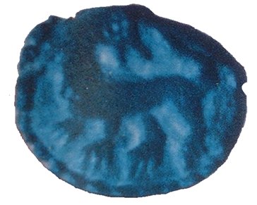
Brooch – would have been used to fasten a cloak.

Blue Brooch

Tools and Implements

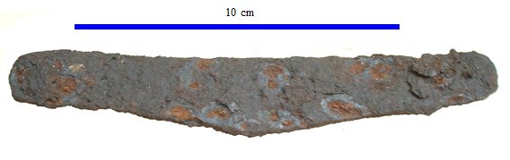
A blade from a woodworking tool

A blade

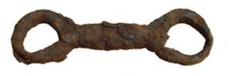
Half a snaffle-bit for a horse of 13 hands

Rusted snaffle-bit

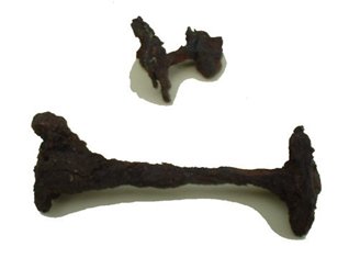
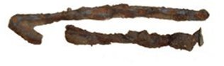
Rivets, probably from a boat

Rusted rivets

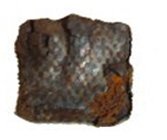
Stirrup fragment with silver overlay

metal fragment

Iron sword guard with decoration beneath its corrosion

Rusted metal sword guard

Lead was cast to form these weights.  They were probably used for oyster-dredging.

Weights with holes in centre

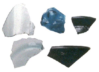
There were fragments of  glass which probably came from pouch-bottles or squat jars.

Fragments of coloured glass

These shavings and off cuts of whalebone show that this material was being made into a variety of items, e.g. a whalebone writing-tablet such as that found at Blythburgh.

Chunks of whale bone

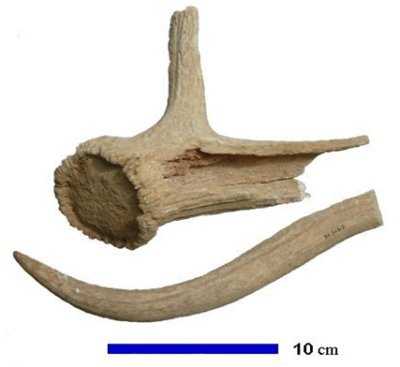
Shed antlers would have been worked into combs and tools

Chunks of antlers with grooves

The tips of one antler tine had been shaped, probably for use in tooling leather.

Parts of antlers

Royal Burial at Sutton Hoo

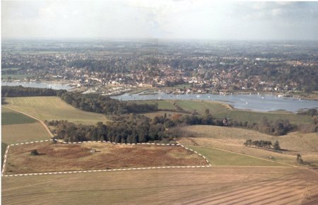
The 17 burial mounds at Sutton Hoo are believed to be the resting place of the early members of the family which ruled the Kingdom of East Anglia.  The mounds are clustered on top of a ridge overlooking the Deben estuary. They are within the area delineated by the dashed white line on the photograph to the right.  Woodbridge is on the other side of the estuary.

The burial mounds date from the early Anglo-Saxon period, and in two of them the remains of a ship was discovered in 1939. The only other instances of ship burials in Britain are at nearby Snape but these were far less elaborate.

The objects found in one of the ships were of such splendour that they must have belonged to a king of high status, and he is believed to be Rædwald who was King of East Anglia until 625. Rædwald had been converted to Christianity but he had not completely abandoned his pagan roots, and this probably accounts for the choice of a pagan burial.

The 17 burial mounds are clustered within the area delineated by the dashed white line.
arial view of burial area

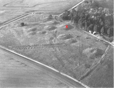
The burial mounds can be clearly seen in the photograph on the right and the X marks the mound in which Rædwald was buried. All the objects which were laid out around his body were for his use in his afterlife. “The unsurpassed richness of the grave goods, and other factors, such as objects, like an iron stand and ceremonial stone, interpreted as symbols of office, leave no doubt that the burial is that of a royal person.”

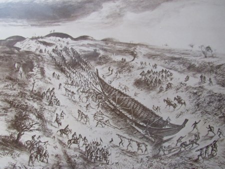
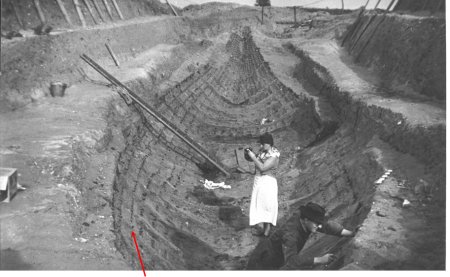
The ship in which Rædwald was laid was probably beached on the riverside below Sutton Hoo, and was then hauled up the hillside on rollers as depicted by the drawing below. By the time the burial mound was excavated, the timbers which had formed the hull had rotted away, and all that was left was a hard layer of coloured sand and the rusted rivets which held the timbers in place. The rivets can be clearly seen in the photograph below. It was taken after the grave goods had been removed.

Black and white photo of burial mounds

Artists impression of the burial boat being hauled up the hillside on rollers.

Artists impression of the burial boat being hauled up the hillside by people

One of the line of rivets which run from bow to stern.

People working in imprinted boat in the ground

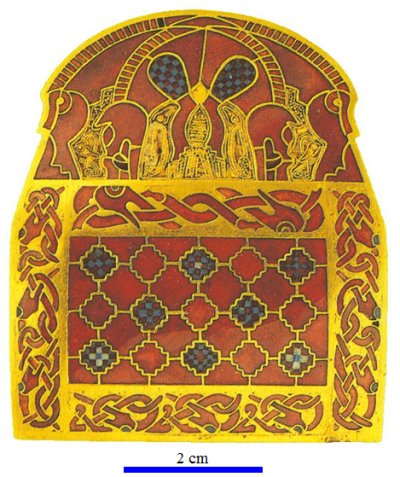
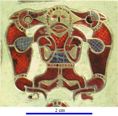
Two of the Burial Items Found at Sutton Hoo

The items which would have been used in the settlements which lined the Deben valley 1200 years ago would have been similar to those found at Burrow Hill. These items are in stark contrast to the richly decorated objects found in the Royal burial chamber at Sutton Hoo.

Shoulder clasp. Cloisonné work with 234 garnet inlays, 10 millefiori inlays and 13 blue glass inlays

Ornate shoulder clasp

Plaque from purse lid. Cloisonné work with 90 garnet inlays and 5 millefiori inlays.

Ornate figure inlaid with red

The First Mention of Woodbridge

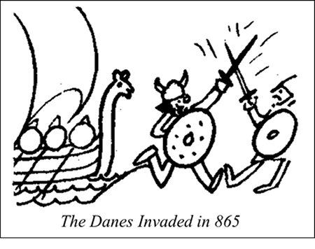
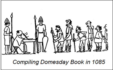
After the Danes invaded in 865 they settled in East Anglia and the northern areas of Britain. Because they destroyed many charters and deeds, all written documents relating to Woodbridge are post the invasion. When the town was first mentioned in 959 it was called Uderdryge. When Domesday Book was compiled in 1085 the town’s name was written as either Uderbrige, Vdebryge, Vdebriga, Vdebriga, Wudebryge, Wudebrige and Wdebrige.
After the Danes invaded in 865 they settled here and destroyed the great body of East Anglian charters and deeds. All written documents relating to Woodbridge are thus post the invasion.
Rudimentary drawing of vikings
The most likely pronunciation of the name of the town is Wudebryge and this is Old Norse for wooden jetty or wooden bridge. The name Wooden Jetty would convey useful knowledge to people sailing up an estuary lined by extensive marshes, whereas any bridge would have been over one of the brooks that ran either side of the ridge on which the church stands, rather than across the much wider Deben estuary. As it is unlikely that such a bridge would be important enough to be conveyed in the name of the settlement, wooden jetty is probably the origin of the name of the town.
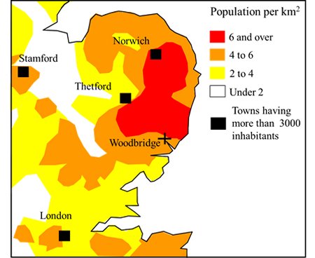
According to the population densities derived from Domesday Book. Woodbridge was on the edge of the most densely populated rural area.
Rudimentary drawing of line of people

The Early Medieval Period

Domesday Book reveals that Suffolk and Norfolk were the most populous shires in Britain by the time of the Norman Conquest.

This map shows how the population density varied across East Anglia. Woodbridge was at the edge of the most densely populated rural area within these counties. Woodbridge was, however, insignificant compared with Walton and Goseford which were at the entrance to the Deben estuary.

According to the population densities derived from Domesday Book Woodbridge was on the edge of the most densely populated rural area in the country.
Map showing population density in East Anglia

Goseford - An Important Maritime Centre at the Entrance of the Deben Estuary

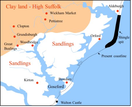
The location of Goseford is shown by this map. Goseford was just an area of the Deben estuary where there were a number of landing areas and secure anchorages. It was a thriving maritime centre by the time of the Norman Conquest and there was a market at nearby Walton.

Walton Castle, near the entrance to the Deben estuary, was one of the homes of the Bigod family who, by the twelfth century were Earls of Norfolk. After the castle at Walton had fallen to Edward I, Goseford became recognized as a base for assembling foreign expeditions.

Other landing places along the estuary, such as that at Woodbridge, were just appendages of Walton.

Goseford and Walton eventually faded away because Woodbridge served a much larger and more diverse hinterland.

Map showing the location and extent of Goseford.

Map pinpointing Woodbridge Market

Founding of Woodbridge Priory and the Market

Woodbridge Priory was founded in 1193. Thirty four years later, it was granted the right to hold a market. By 1300 all the towns on the map on the right had markets but only those at Woodbridge and Wickham Market survived beyond the start of the sixteenth century.

Across the country the markets which survived were the ones that had good transport links to the main urban centres. The long navigable estuary made Woodbridge the natural outlet for the coastal Sandlings and the heavy clay lands of “High Suffolk”.

Woodbridge Priory was granted the right to hold a market in 1227. By 1300 all the towns on this map had markets but only those at Woodbridge and Wickham Market survived beyond the fifteenth century.

More on The Priory

An Augustinian Priory was founded at Woodbridge, in 1193, by Ernald Ruffus on land granted by the Bigod family. (The Augustinians came from Normandy). The Priory was also given other land in Woodbridge, Hasketon, Burgh. The head of the Priory was called a prior and he would have had the same control over the people who lived in the land granted to the Priory as did any other manorial lord. All inhabitants (tenants) of the Manor of Woodbridge Priory thus had obligations to the prior and they had to spend a specified time working on his land. In return they would be given a small amount of land on which they could grow food for their families.

Woodbridge Priory was small, and it probably never had more than the prior and about 12 canons whose main duty was to go out and preach in the surrounding communities. The Priory, the building in which they lived, was built adjacent to the much later St Mary’s Church in Woodbridge. The canons did not have a church of their own, they shared the church in Woodbridge with the townspeople for over 200 years.

There had been a Tide Mill by the riverside from at least 1171 when Baldwin of Ufford granted tithes, from his mill in Woodbridge, to the canons of Butley Priory. Then, sometime between 1195 and 1213, Butley Priory transferred these tithes to Woodbridge Priory.

The Priory acquired market rights for Woodbridge in 1224. This gave the Priory the right to organize a market and to levy tolls on those selling goods at it. Soon after the market became established it is likely that Woodbridge began to flourish as a port which exported the produce grown in the surrounding country side.

In 1436 the Lord of the Manor of Woodbridge Ufford (then Robert Willoughby) granted the “Key and Pool” to the Prior of Woodbridge and the canons thereby became owners of the Tide Mill. Their venture by the waterside would have brought benefits to the Priory and would have strengthened the links between the seafaring community of the town and the canons.

The relationship between the Priory and the townspeople appears to have been harmonious. Woodbridge wills contain a number of bequests to individual canons and, when the peasants rose in revolt in 1381, they marched through the town without rioting or touching the Priory. Surrounding areas weren’t so lucky. The Manor houses of Melton, Bawdsey and Hollesley were burnt and the Court Rolls and taxation records destroyed.

The people of Woodbridge were also prepared to help the Priory pay for repair costs to its water mill and they lent money to maintain the mill-pond and the river banks. But ultimately the mill and its upkeep put a great strain on the limited resources of the Priory and eventually the poverty of the House was attributed to the expense of maintaining the tide-mill and the mill banks.

Maritime and other commercial activities brought wealth to the town and by the mid-fifteenth century merchants had funded the building of the new parish church of St Mary’s in fine perpendicular style. Work on the chancel and the nave started in about 1417 and they were finished about 27 years later. The Anglo-Saxon church was left standing for the use of the Priory.

In 1532 Bishop Nykke, after one the regular visitations (inspections) that Bishops made of monastic houses, reported that Woodbridge Priory was in debt and disrepair and that the Priory Church was in ruins. This was not a good time for such a negative report to be made. Five small Suffolk monastic houses had been among the 30 confiscated in the 1520’s by Cardinal Wolsey to support his great educational schemes at Oxford and Ipswich and by 1530 Henry VIII was looking for additional income to fund improved defences against invasion by the French and the Spanish. In 1536 Parliament passed an act which lead to the critical inspection and subsequent dissolution of many of the smaller monasteries and, from 1538 to 1540, the remaining smaller houses and all the larger houses were persuaded to close and surrender their property to the King.

Woodbridge Priory was dissolved in 1536 and Henry Bassingbourne, the last prior of Woodbridge, became Rector of Melton. He had been appointed Prior in 1530. Four years later he, like most of the clergy, swore allegiance to Henry VIII as Head of the Church in England.

Many of the early monasteries to be dissolved were given to supporters of the King. In 1536 the Duke of Norfolk, who had already received a gift of 13 rich abbeys, requested Woodbridge Priory as well. His request was refused but he appears to be granted some of the land the Priory used for its garden. These lands were later passed to Thomas Steynings, of Woodbridge.

The rest of the Manor of Woodbridge late Priory was leased, in 1538, for 21 years to Sir Anthony Wingfield of Hasketon and in 1547 it was transferred to Sir John Wingfield. On the death of Sir John in 1549 his widow Dorothy became Lady of the manor.

The Priory Church was is believed to have been demolished in 1542 and it is probable that the Priory buildings suffered the same fate at that time.  However, the Suffolk Historian, Vincent Redstone, was convinced that the Priory Church and St Mary’s stood side by side and that were joined along the south wall of the Chancel of St Mary’s.

The distance between the Chancel wall and the boundary wall of the churchyard is only 10.7m at its widest point and it narrows to 7.2m.  It is thus likely that there was space for the Priory Church.  It is not known the when the Priory Church was eventually demolished, but when it was the boundary wall was coated in cement and there were inscribed lines to make it look like blocks of stone.

The boundary wall of the churchyard appears to be unchanged.

In 1564 Queen Elizabeth granted the Manor of Woodbridge late Priory to Thomas Seckford “In consideration of the sum of £764 8s 4d”.

It was Thomas Seckford who constructed the imposing town house which he called The Abbey to give it added status. In order to lay out a park around The Abbey, Seckford had to buy the land which had formerly been the Prior’s garden from Thomas Steynings.

Whether or not The Abbey was built on the part of site of the former Woodbridge Priory has long been a matter of dispute. The discovery of some human bones when alteration were made to The Abby, in 1912, to create a long room, has been taken by some to indicate that the site was formerly the burial ground of Woodbridge Priory and not of the former Priory building. An alternative view is set out below.

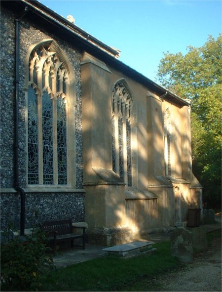
This photograph shows that the south wall of the chancel of St Mary’s Church is rendered with cement. It is the only part of the exterior of the church not to be finished with knapped flint.

South wall of the chancel of St Mary's Church is rendered with cement.
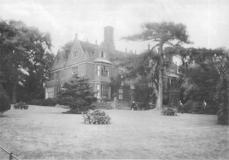
Rear view of The Abbey in 1885.
Rear view of The Abbey, Woodbridge

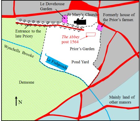
In 1560 a document called an Extent was produced to detail the lands held by the Manor of Woodbridge late Priory. Although the Priory had been dissolved 34 years previously, the Extent contains references to the land surrounding the former priory. From this information it has been possible to produce the map on the right. The roads in the centre of the town were the same as they are today. Those shown in red on the map to the right are based on those on the 1871 OS map. The grey area is where there was housing in 1560. The lime green area was part of the demesne of the manor, the land which the tenants of the manor were obliged to cultivate for the lord of the manor. The blue grey area was mainly parcels of land held by other manors.

The area within the dotted line appears to be extent of the garden around the Priory. It encompassed a large pond referred to as Le Fishponds which is where the canons would have bred fish. The pond depicted on the right is based on the one depicted on an 1827 map so it is important to stress that this pond may not be the same as the one which was there in 1560. It could be that the Le Fishponds was enlarged a few years later to provide the clay needed to make the bricks needed to build The Abbey. It is also possible that Le Fishponds may have been further up Wynchells Brook and the large pond on the map was one created to make the bricks.

By Le Fishponds there was an area called the Pond Yard and nearby there was an area called the Prior’s Garden. There is also a reference to Le Dovehouse Garden which was probably associated with the Priory.

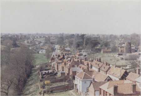
The entrance to the Priory was along a path which ran to the south of Fishpond Street (now Seckford Street). This tree line path is clearly shown on an 1827 map of the town and about that time it was being called Monk’s Walk. The entrance to the path has long been blocked off but the trees which lined it remain standing and can be seen in the photograph on the right.

The other end of the path is very near the site on which the house named the Abbey was built in the late 1560s. This site is also very near to (i) the former Anglo-Saxon church which once adjoined the southern side of the Chancel of St Mary’s Church and (ii) a house which had been occupied by the Prior’s farmer (who was presumably responsible for overseeing the tenants who cultivated the demesne of the manor). On the basis of this evidence it seems likely that The Abbey was very near the site of the former Priory.

Map, based on the 1560 Extent, of the area around the site of the former Priory
Map of the area around the site of the former Priory

View from the top of St Mary’s Church. The trees on the left line the path called Monk’s Walk.

View from the top of St Mary's Church, Woodbridge

The Initial Devastation of the Black Death and the Recovery which Followed

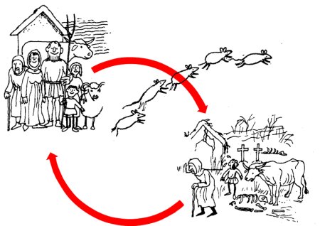
The first wave of the Black Death, which was spread by fleas carried by rats, swept through Suffolk in 1349. It, and the waves which followed a few years later, killed between a third and half the population which then remained almost constant for the next two centuries.

The initial impact of the Black Death was devastating but the fall in population resulted in peasants having more land. Consequently their living standards eventually improved and they wanted better quality food, beer, clothing and footwear.

Woodbridge was well placed to provide the food and materials needed and trade through the port thus increased.

The Black Death was brought by fleas carried by rats. Its initial impact was devastating but the large fall in population eventually resulted in living standards improving.

The Building of a New Parish Church

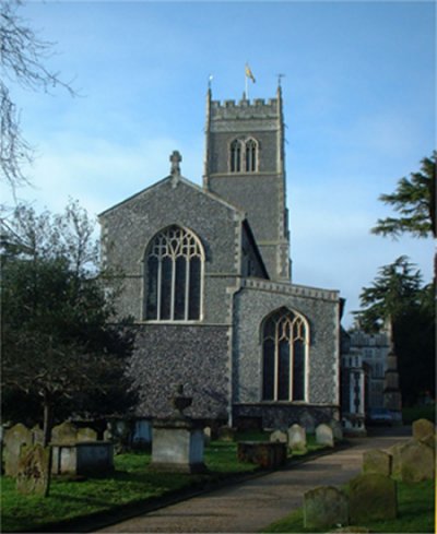
The increased maritime trade made some Woodbridge Merchants very wealthy and they funded the building of the new Parish Church of St Mary’s in fine perpendicular style. Work on the church, which is shown here, started in 1417 and finished in 1465. The original Anglo-Saxon church remained for the sole use of the priory and the two churches stood side by side.

The priory was dissolved in 1537 and the Anglo Saxon church was demolished 5 years later. It is likely that the priory’s other buildings suffered the same fate at that time.

The land formerly held by the priory reverted to the Crown and became the manor of Woodbridge late Priory.

Work on building St Mary’s Church started in 1417 and ended in about 1465.
St Mary's Church, Woodbridge

Woodbridge in 1524

By 1524 the towns in Suffolk where woollen cloth was made were becoming prosperous.

The port at Dunwich was in decline because of coastal erosion and this boosted the maritime trade of Woodbridge, Southwold and Aldeburgh.

On the right there is a list of the 25 Suffolk towns and villages whose inhabitants paid the most tax in 1327 and in 1524. The towns and villages are ranked in order of the amount of tax they paid. In 1524 Ipswich paid the most tax and Woodbridge is 10 places below it. The names of the towns which were ports are printed in blue.

Suffolk towns and village listed in order of their wealth in 1327 and 1524. The ports are italicised.

1327 

1. Ipswich
2. Bury St Edmunds
3. Sudbury
4. Beccles
5. Hoxne
6. Mildenhall
7. Eye
8. Stradbroke
9. Long Melford
10. Fressingfield
11. Dunwich
12. Hadleigh
13. Orford
14. Walton/Goseford
15. Mendlesham
16. Lavenham
17. Bungay
18. East Bergholt
19. Needham Market
20. Stowmarket
21. Blythburgh
22. Brandon
23. Haverhill
24. Woodbridge
25. Debenham

1524

1. Ipswich
2. Lavenham
3. Bury St Edmunds
4. Hadleigh
5. Beccles
6. Long Melford
7. Sudbury
8. Nayland
9. Stratford St Mary
10. East Bergholt
11. Lowestoft
12. Woodbridge
13. Dunwich
14. Bures
15. Bungay
16. Stoke by Nayland
17. Glemsford
18. Southwold
19. Blythburgh
20. Boxford
21. Stowmarket
22. Aldeburgh
23. Needham Market
24. Debenham
25. Clare

Woodbridge in 1560

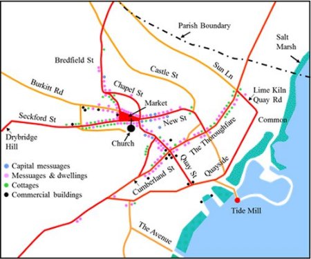
In 1536 Woodbridge Priory was dissolved and both the priory building and the nearby Anglo-Saxon church were soon demolished. A document called an Extent was produced, in 1560, to detail the holdings of the manor of Woodbridge late Priory, and from it the map to the right is derived. All the roads shown still exist today although most of their names have changed. The modern names are used here to avoid confusion. The houses which lined the streets were described (in order of grandeur) as capital messuages, messuages, dwellings and cottages.
Map of the town based on the information given in the 1560 Extent. The road names are those used today.

The Buildings in 1560

Some of the houses in Woodbridge would not have been listed in the Extent because they were on land belonging to another manor. When allowance is made for this, it is estimated that there were 215 houses in the town in 1560. All of them would have been timber framed.

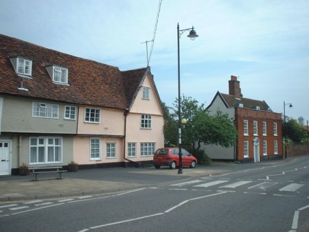
There are still 153 timber such houses in the town today but most of them, like the one of right of this picture, have an early 1800s brick facade. The timber framed house on the left is still in its original state.

On the left of this photograph there is a timber frame house which is still in its original form. On the right there is a timber framed house which has had a brick facade added.
Woodbridge timber framed houses today

The Riverside in 1560

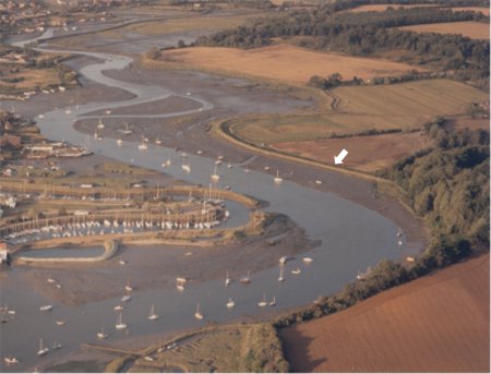
From the Extent it is clear that, in 1560, the riverside was lined by extensive marshes. The river walls were not built until the early seventeenth century. Part of the river wall on the far side of the estuary is marked by a white arrow on the aerial photograph to the right. The photograph shows the stretch of the Deben from the quays by the Tide Mill to the bridge at Melton. The river wall enabled the low lying land to the right to reclaimed. The mud and saltings to the left of the wall are covered at high tide. The river walls also confined the river and thereby eventually deepened it. This had a significant impact on maritime trade.
The river wall (arrowed) on the far side of the estuary can be clearly seen on this aerial view of the Deben from the tide mill yacht harbour to the bridge at Melton. The building of the river wall enabled the low lying land to the right of it to be reclaimed. The mud and saltings to the left are covered by water at high tide.
Aerial view of the Deben river from the tide mill yacht harbour to the bridge at Melton

Maritime Trade in the Sixteenth and Seventeenth Centuries

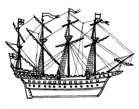
During the 1500s most of the ships using the port were less than 30 tons. By the mid 1600s, after the building of the river walls, much larger ships were able to reach Woodbridge. The Prosperous Mary, for instance, loaded 171 tons of provisions for the Parliamentary army in Scotland. By this time most ships were galleons. A drawing of a late sixteenth century galleon is shown here.
A late sixteenth century galleon.
From 1550 to 1650 the population of London increased tenfold and Suffolk was well placed to meet the rise in demand for food. Maritime trade steadily increased and, in 1589, a customs house was established on one of the quays. By 1661 an ‘iron house’ on one of the quays was then being used as a customs house. In the late 1700s the customs house was moved to this building on Quay Street and it remained there until Woodbridge ceased to be classified as a Port.
The former Customs House on Quay Street.

During the 16th and 17th centuries the total amount of tax paid by the inhabitants of Woodbridge continued to overtake that some other Suffolk towns and villages.

In these lists the towns and villages are ranked in order of the total amount of tax paid by their inhabitants in 1524 and 1674. Over this period Woodridge rose from being the 12th on the list to 5th. The ports are italicised.

By mid 1600s the importance of Suffolk to the economy of the county was decreasing and volume of outgoing goods was falling. This was, however, partly offset by a rise in incming goods such as coal and timber.

Little is known about Woodbridge’s maritime trade during the rest of the 1600s and during the 1700s. The story thus has to skip to the 1800s.

Suffolk towns and village listed in order of their wealth in 1327 and 1524. The ports are italicised.

1524

1. Ipswich
2. Lavenham
3. Bury St Edmunds
4. Hadleigh
5. Beccles
6. Long Melford
7. Sudbury
8. Nayland
9. Stratford St Mary
10. East Bergholt
11. Lowestoft
12. Woodbridge
13. Dunwich
14. Bures
15. Bungay
16. Stoke by Nayland
17. Glemsford
18. Southwold
19. Blythburgh
20. Boxford
21. Stowmarket
22. Aldeburgh
23. Needham Market
24. Debenham

1674 

1. Ipswich
2. Bury St Edmunds
3. Hadleigh
4. Beccles
5. Woodbridge
6. Mildenhall
7. Long Melford
8. Lavenham
9. Sudbury
10. Bungay
11. East Bergholt
12. Framlingham
13. Stowmarket
14. Stoke by Nayland
15. Lowestoft
16. Mendlesham
17. Stradbroke
18. Boxford
19. Aldeburgh
20. Halesworth
21. Nayland
22.Newmarket
23. Eye
24. Debenham

Maritime Trade from 1800 to 1850

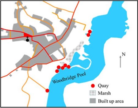
By 1801 Woodbridge was the 4th most populous town in Suffolk. The maritime trade was past its peak but all the quays shown on this map of the town in 1827 were busy. Two other quays were outside the area covered by the map. One was at Kyson Point to the south and the others were at Melton to the north.
Map of the town and its quays in 1827
Map Woodbridge and its quays in 1827
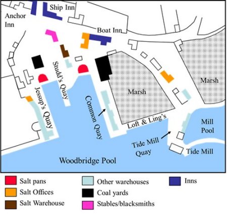
The main cluster of quays all served that area of the estuary called the Woodbridge Pool and they are shown in detail by this map. Nearby the quays there were warehouses and salt pans. Salt had been collected from the gullies along the Deben for centuries and it was refined in Woodbridge until the late 1700s.
The quays serving Woodbridge Pool in 1827.
Map of the quays serving Woodbridge Pool in 1827.
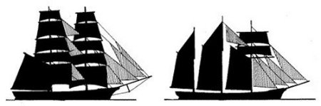
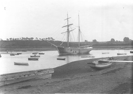
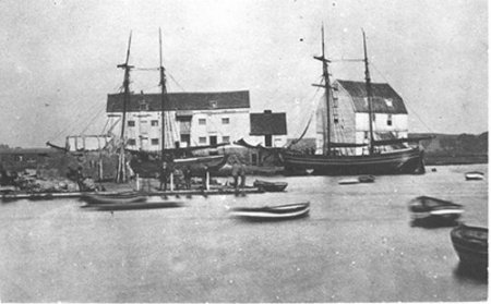
Corn was the principle export of the town and the principle imports were coal, oil cake (for cattle food) and timber from the Baltic. The vessels engaged in the trade were brigs and the more commodious topsails schooners. From the early part of the 19th century topsail schooners dominated trade. The photographs below show at topsail schooner at anchor in the Woodbridge Pool and two along side the Common Quay.

Left silhouette of a brig, right silhouette of a topsail schooner

A topsail schooner at anchor in the Woodbridge Pool.
Black and white photo of a topsail schooner at anchor in the Woodbridge Pool.
Two topsail schooners at the Common Quay.

The Pilots of The Deben

It would have been no mean feat to navigate large vessels over the bar at the entrance of the estuary and through the tortuous reaches beyond. It was thus necessary to employ local seamen who had a detailed knowledge of the area to pilot large vessels. Eventually these pilots were licensed by Trinity House.

The Corporation of Trinity House of Deptford Strand was created in 1514 and it eventually became the principal maritime authority in the UK. It had general powers to organize pilotage and, from 1604, the exclusive right to licence pilots on the Thames. A system of ‘outports’ was not formally created until 1808 and it is from that year that a comprehensive record of examination and licensing of pilots began. Each pilot had to renew his licence yearly when his general health, eyesight and knowledge of local waters were tested. The Corporation financed its pilotage service from the fees paid by vessels and it retained its right to organize pilotage until 1988.

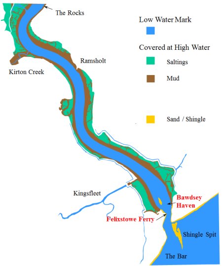
From 8 June 1847, the Corporation exercised its right to pilot ships and vessels into and out from “the sea over the bar into Bawdsey Haven and up the River Deben to Woodbridge and vice versa”. From that time there were Trinity pilots at Woodbridge and at Felixstowe Ferry.

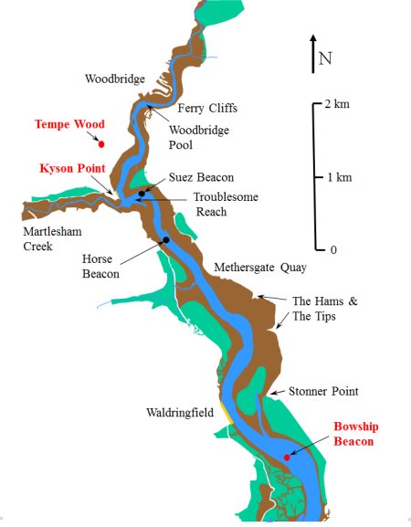
The approach to the Port of Woodbridge has a line of 15 beacons (buoys) marking the channel through the mud flats. It is not known when these beacons were put down but some were there by 1847. (There would have been much earlier channel markers, especially when the half-finished hulks of Woodbridge built men-of-war were taken down stream in the seventeenth century, but nothing is known of them.) The locations of some of these beacons are shown on the map on the right. The first of them is called the Bowship Beacon. It was the point where the Woodbridge pilots took over from those at Felixstowe Ferry.

The Woodbridge pilots kept watch from Tempe Common which was at the top of a ridge running down to Kyson Point. From there they could look down river. When a ship was sighted, a pilot would walk along a path skirting Tempe Wood to his lug-sail boat moored at Kyson point. From there he would sail down river to the Bowship Beacon.

In 1856 there were a total of 12 pilots stationed at either Woodbridge or Felixstowe Ferry. By 1871 their number had dropped to 11 and by 1873 to 6. The records from which this data has been obtained ended in 1903 and by then there were still 6 pilots. All the pilots were local men with many years of experience. In 1861 the ages of the 6 pilots stationed at Woodbridge varied from 34 to 65 and their average age was 47.

The extent of the Deben Estuary at low and high tide and the locations of the main beacons marking the deepest channel.
Maps of North Woodbridge Deben estuary, showing low and high tide
Maps of South Woodbridge Deben estuary, showing low and high tide

Wilford Bridge was built in 1530. Prior to this it was only possible to cross the river at low tide by using stepping stones. In 1764 the bridge was demolished and replaced by a brick structure. It soon became apparent that there were problems with the structure so the bridge was rebuilt with white brick. In 1939 the old bridge was declared unsafe and the road was closed whilst a new one was built at a different angle. Melton quay was established near the bridge in 1840 to receive stone for the roads.

Ferry Cliffs were above the landing place for the Woodbridge ferry. This ferry served the Sandling villages long before Wilford bridge was built. The bridge did not remove the need for the ferry because it was still quicker for many of those walking to Woodbridge Market. The ferry ran from the Quay at the Tide Mill to near Sutton Cliff until the present river wall and landing place were made in 1874. The ferry originally belonged to Manor of Stockerland-in-Sutton, and the first recorded ferryman was John Beal who in 1509 paid an annual rent of 6s 8d. As Woodbridge increased in importance, the Lord of the Manor of Woodbridge-late-Priory acquired some control over the ferry, presumably because the Ferry Quay was manor property.

Victorian families used the Woodbridge Ferry to reach the picnic area on the Sutton Cliffs. In the late Victorian era the ferry was a vital link in preserving the respectability of Woodbridge residents. The male population were allowed to swim on the Sutton side of the river where a sandy beach then existed below the Sutton Ferry Cliff. The ladies swam behind the Tide Mill where there was a caravan in which they could change into their bathing costumes.

The rights of the ferry were given to Woodbridge Urban District Council in 1919 and the demand for the ferry was such that, right up to Second World War, the ferryman paid for the privilege to operate it. After the war it became a service supported by a grant from the Council but few people used it. In 1950 the Urban District Council announced that they were going to stop the ferry because so few people wanted to use it but they were prevented from doing so by a High Court Action. The ferry continued until 1974 when the new Suffolk Coastal District Council stopped paying for it.

Tempe Common is at the top of the ridge running down to Kyson Point. The Woodbridge pilots kept watch from Tempe Common because from there they could look down river. When a ship was sighted, a pilot would walk along a path skirting Tempe Wood to his lug-sail boat moored at Kyson point. From there he would sail down river to the Bowship Beacon.

Kyson Point is part of the Royal Manor of Kyson. When the Anglo-Saxons used the Deben estuary most of it was lined by extensive salt marshes and the beach on the Woodbridge side of the Kyson point was probably the highest point up the estuary where longboat could land and thus became the place where people came to pay their food rents to the king.

In 1622 Thomas Warner of Parham sailed from the shores of Kyson to St Kitts in the Leeward Islands to grow tobacco. This voyage was the start of Britain’s West Indian expansion. In the eighteenth century some of the loaded schooners bound for Lime Kiln Quay ships had to be lightened by having some of their cargo taken off at Kyson by smaller boats (lighters). By 1844 all the buildings on Kyson point were associated with a brickyard run by William Colchester and Co.

Martlesham Creek, which leads to the River Finn, is now only navigable for a short distance but once possible to go further, maybe as far as Burg near Grundisburgh. The Roman villa there may have been a country house of the Counts of the Saxon Shore who had their fortress at Walton and could have ascended to Burg on the tide. Crossing the Finn was the sede-ford or seckfod, which is the derivation of the name Seckford -Woodbridge’s Tudor benefactor. This ford was superseded by the Mediaeval bridge. Martlesham Church, like many others along the Deben, was built by a creek so that building material might be brought to it via the water.

Suez Beacon and Lower Troublesome Beacon mark the twist in the channel opposite Martlesham Creek and the entrance to that section of the river known as Troublesome Reach. It has been so called for untold years owing to the fluky winds that come down from the creek making it a particularly troublesome reach to beat up. Suez Beacon stands at the entrance to a channel called Loder’s Cut which was dug through the mud in 1879; a few years after the great Egyptian water way was opened.

Horse Beacon marks the place where a ships voyage from Woodbridge was deemed to begin. Thus arose the custom of ‘wetting’ the horse by breaking a bottle to wish good luck to the voyage. It also marked the end of a voyage. Fires were lit when the beacon was passed and food put on the stove to cook. If the ship were becalmed hereabouts, the crew were allowed to go home.

Methersgate Quay was probably a manorial landing-place of the Manor of Campsey. From the quay there is an old track way across the heath to Ufford, Staverton and Butley. By 1844 there was a brickworks near by.

The Hams and the Tips These sandy tips were built out into the river during the latter part of the 19th century by Robert Cobbald, a Sutton farmer, in an endeavour to reclaim 150 acres of land. He was eventually stopped by Trinity House who feared that the tips would alter the course of the river and hence interfere with navigation.

Stonner Point was once a manorial landing place. Around 1850 Stonner Quay was established for the shipping of Coprolite. These phosphate nodules formed in the layers of excreta and bones on the bed of the sea which covered this area. Thousands of tons of this ‘dung stone’ were shipped annually from Deben side Quays to all parts of the kingdom. The trade died out in about 1895 with the advent of new kinds of fertilisers.

Waldringfield In 1876 a factory was established at Waldringfield to make Portland Cement from common chalk and river mud (ooze). When the factory was in full swing it had 7 kilns and a fleet of 7 sailing barges trading between the Waldringfield Cement Works and the Thames. At times as much as 400 tons a day was loaded. The factory was supplied with mud by the barge Kingfisher. Two men used to take her down river to just below Waldringfield and, in one tide, load her by hand with 25 tons of mud from the saltings. The cement works was owned by “Masons Portland Cement” who also had a much larger complex at St Peter’s Timber Yard in Ipswich.

The Rocks This reach of the river takes its name from the hard rocky bottom made up of Septaria. These limestone nodules are a form of fossilised jellyfish and there are also large deposits at the foot of Felixstowe cliffs. This stone, called “Rockstone”, has been used for building. Orford Castle was made from it and Cardinal Wolsey used it for his College at Ipswich. In the nineteenth century demand for the stone much increased because it was used in the manufacture of cement

Kirton Creek There was a ferry from Kirton Creek to the other side of the river. The field above where it used to land was known as Ferry Hemp-land. Most Suffolk villages had their hemp-lands. They originated from the time of Queen Elizabeth when anyone who farmed more than 60 acres was obliged by law to grow a crop of flax or hemp.

There were salt pans on the extensive salt marshes that ran from Kirton Creek to Waldringfield. The salt collected in these pans was sent to Woodbridge for refining.

Ramsholt Church commands a fine view of the entrance to the Deben. There are 41 such towers in Suffolk and it is believed that they are of the period of the Danish Invasions and that they were built for defence. Ramsholt church tower could have been a look out post to provide warning of Viking raids.

Kingsfleet is now a large drainage ditch but in Norman times, before the river wall was built, the area was an expanse of sheltered water behind the high ground of Walton and Walton Castle. This area of sheltered area water was a natural harbour of the port of Goseford. The castle was one of the homes of the Bigod family who, by the twelfth century, were Earls of Norfolk. After the castle had fallen to Edward I, it was replaced by a royal manor and Goseford became recognized as a base for assembling ships for foreign expeditions. In Suffolk fleet means shallow, so Kingsfleet was simply the shallow creek used by the Kings. Alternatively the name might just reflect the fact the area was one used by kings to assemble their fleets.

Bawdsey Manor overlooks the entrance to the Deben. It was finished in about 1886 having taken some 18 years to build. It was the hub of Sir Cuthbert Quilter’s 8000 acre estate which extended almost to Woodbridge. He was a stockbroker, financier and politician. In 1936 the manor was used as a top secret research establishment and it was here that the radar system, which played a pivotal roll in the Battle of Britain, was developed. The Manor remained an RAF station until 1991.

The Bar The shingle banks which line the entrance of the Deben change their shape and direction every year but, if old charts are to be relied upon the depth of water over the bar between them has hardly changed over the last 400 years.
Wilford Bridge
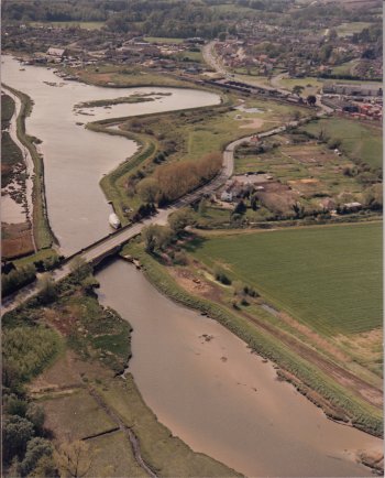
Above Woodbridge Pool looking up to Wilford Bridge
Aerial view photo above Woodbridge Pool looking up to Wilford Bridge
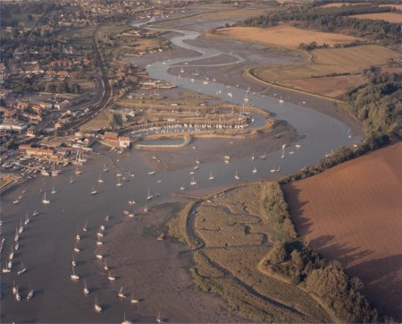
Looking towards Kyson Point. Martlesham Creek goes off to the left and the entrance to Woodbridge pool is on the right.
Aerial view looking towards Kyson Point. Martlesham Creek goes off to the left and the entrance to Woodbridge pool is on the right.
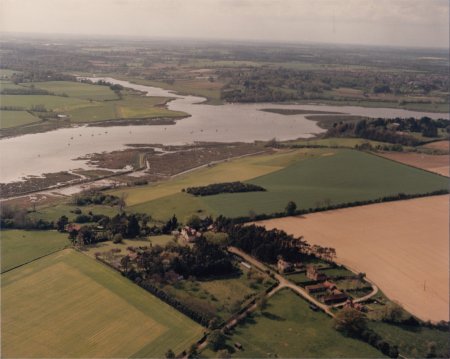
Looking down river from above the bank opposite Kyson Point.
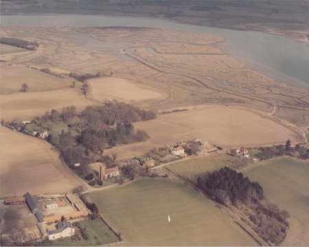
Aerial view looking down river from above the bank opposite Kyson Point.
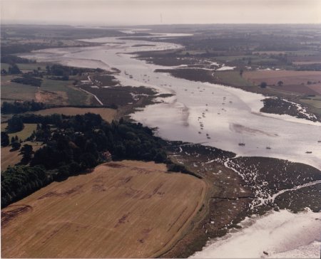
Looking up river from above Hemley
Aerial view looking up river from above Hemley

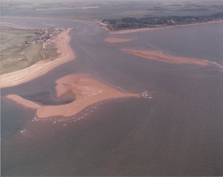
The shingle banks which line the entrance to the Deben estuary.

Aerial view of the shingle banks which line the entrance to the Deben estuary.
By 1952 commercial traffic on the river had faded away and so had the need for a Woodbridge Pilot. The last of the Trinity House Pilots for Woodbridge was Frank Knights. In the 1940s he took over the job from Ted Marsh, who had served for 40 years on square-rigged sailing ships before returning to Woodbridge to become a pilot.
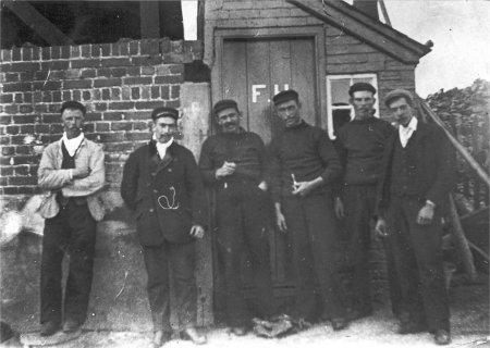
The Woodbridge pilot F Adams is on the left of this photograph which was taken around 1900. The four men on the right are probably ‘huffers’ who unloaded and loaded vessels.
Black and white photo of a a pilot and huffers from around 1900

Woodbridge Seaman’s Benevolent Society

The heavily rigged little schooners on which the trade of the port depended during the first half of the nineteenth century had a bad habit that worried the town’s conscience. They often sailed off into the cold grey North Sea and did not come back. The loss of men at sea, and the hardship it caused their families, could not pass unnoticed in a small community.

In 1840 a group of worthies formed the Woodbridge Shipwrecked Seaman’s Benevolent Society to give financial aid to the relatives of drowned seamen and to compensate for any personal ‘gear’ lost. Most of the money was collected through donations from wealthy residents. By 1874 the society had 174 seafaring and 245 honorary members and it paid about £133 a year to 29 widows. Payments continued until the closure of the society in 1910. Some of the annual reports of the society are in the Woodbridge museum’s collection.

Reminisces of Maritime Trade in the Early Nineteenth Century

Writing about Woodbridge during the early part of the nineteenth century a resident, William Lockwood, recalled that ‘The market at that time was held on a Wednesday, and on the following, and for several succeeding days, wagon loads of corn that had changed owners in the market, might be seen coming in by twenties and by fifties, if not by hundreds; and the quays would be thronged with men, wagons and horses shooting corn into the holds of vessels lying in the docks, which were generally full of craft, some loading for London, some for Liverpool, and some for Newcastle or another large port in the North.

Lockwood goes on to say ‘Other vessels would be lying in the river, perhaps laden with coal, waiting for an outward bound vessel to make room at the quays for them to unload their cargoes of coal. At that time there was a duty on sea-borne coal, and two or three sworn government meters had to be employed, and were generally at work all day long measuring every bushel or basket of coal as it was pulled up out of the hold.’

Lockwood’s account ends thus ‘Loaded corn wagons making their way down to the quays, and the empty corn wagons and coal laden ones returning, would all the morning throng the streets, or the approaches to the quays. The farm men from distant parishes used to start overnight so as to arrive in early morning, coming from Hoxne, Eye, Diss, Stradbroke and such places over 20 miles, in order to give their horses a good rest, and to get back before dusk on the next day, generally having to take a return of coal, timber, shop goods and lime.’

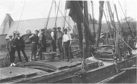
Unloading coal from a barge. The two government meters can be identified by their pristine while collars and one has white shoes.
Black and white photo of men standing on a barge.

All the hard work at the quays would have created a thirst but nearby there were three pubs, appropriately named, The Ship, The Boat and The Anchor, to deal with that. The Ship and The Boat long since closed and are now houses but photographs below show them when they were still open.

The Ship is in the centre of this photograph which was taken from a yard by the side of The Boat. The Anchor can just be seen on the left.
The Ship pub in Woodbridge

This photograph show the rear of The Boat. For many years a gypsy lived in the caravan on the right.

The Boat pub in Woodbridge
The Bell and Steelyard, a public house on New Street, was also important to the maritime trade. It was where loaded carts were weighed when they were on route from the market to the quays. The steelyard is on the right hand side of this photograph.
The Bell and Steelyard on New Street.
The Bell and Steelyard on New Street, Woodbridge

Maritime Trade from 1850 – A Period of Terminal Decline

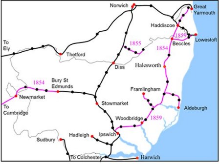
By 1859 the rail network in Suffolk was as shown on the right. The lines in black were all in service by 1849 while those in purple became operational on the dates shown.
The extent of the rail network in Suffolk by 1859. The lines which were built from 1849 to 1859 are shown in purple.
Map of rail network in Suffolk in 1859

In order to keep the tracks as level as possible, the railway ran on the flat ground alongside the Deben estuary and skirted the top of the quays serving the Woodbridge Pool. The impact on the quays is shown on the right by overlaying the station and the tracks onto an 1827 map.

The railway tracks and station superimposed in red on an 1827 map of the quays.
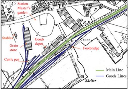
The railway had extensive goods sidings, a goods depot, cattle pens and a large grain store. These are all highlighted on the extract of the 1881 Ordnance Survey map shown on the right. The main up and down lines are coloured green while the goods lines and extensive sidings are blue. A goods line from the marshalling yard went to quays which were up river.
Plan of the railway station in 1881. The main up and down lines are coloured green while the goods lines and extensive sidings are blue
Plan of Woodbridge railway station in 1881.
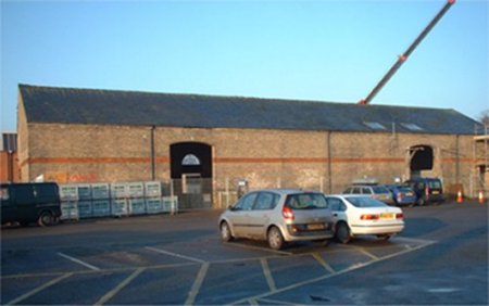
This photograph shows the grain store just before its conversion to a number of commercial units. Carts delivered corn to the large entrances and it was stored under cover before it could be loaded into railway wagons.
Woodbridge grain store building
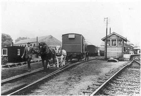
Horses were used to pull wagons on the goods lines by the station and along the goods line running to the quays up river.
Horses pulling wagon on rail tracks.

The Impact of the Railway on the Port

After the railway was built the maritime trade of the port started a protracted decline. From about 1860 ketch barges such, as the one shown in this photograph, replaced schooners because they required less crew and were of smaller draft. Nevertheless, the number of vessels using the port declined and the number leaving without a return cargo increased.

A ketch barge leaving Woodbridge.
Ketch barge
Eventually, on 31st March 1882, Woodbridge ceased to be officially classified as a port but this did not stop some barges, such as the one shown in this photograph, from using the Woodbridge quays.
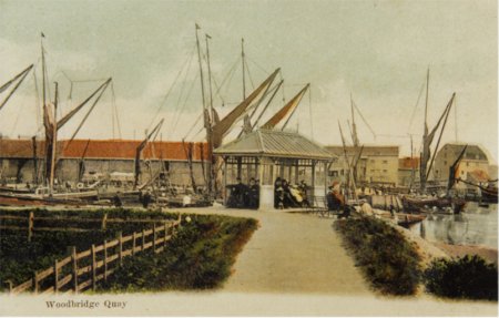
A ketch barge by Woodbridge Station circa 1920.
Ketch barge circa 1920
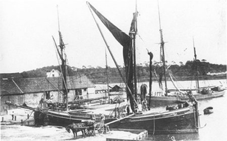
Robert Skinner used barges to sell coal along the riverside to people who found it more convenient than collecting coal from Woodbridge or Melton railway stations. The last work he could find for his barges was to carry shingle up from the Deben Bar for building material. He died in 1935 and after that, as shown by this photograph, the quays were full of laid-up barges.
Woodbridge quay photograph
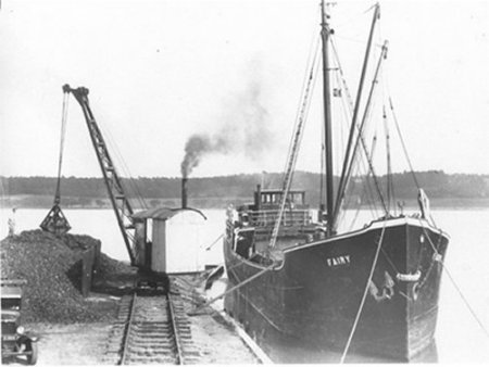
What remained of the town’s maritime trade was left to the steamers such as the Fairy which, in this photograph, is delivering coal to Sun Wharf.
The steamer Fairy unloading coal at Sun Wharf.
Steamer boat delivering coal
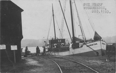
Dutch coasters, such as the one shown here, brought cargoes of dried peas to Woodbridge’s Canning Company warehouse at Sun Wharf for a number of years but their final delivery in 1939 marked the end of Woodbridge’s maritime trade.
A Dutch coaster delivering dried peas to the Woodbridge Canning Company’s warehouse at Sun Wharf.
A Dutch coaster delivering dried peas near rail track